In September, 2013, I spent seven days travelling in Québec and the Charlevoix region in Canada’s Québec province. I joined a guided walking tour operated by a company named CW. Our small group included a local guide Yannick and five travelers from America. I walked the streets of Québec, tasted the local cuisines, hiked in national parks, and watched whales in the Saint Lawrence River.
old city
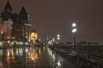
Old City
The four-century old Québec, the provincial capital, is located on the shore of the Saint Lawrence River. I spent my time exploring and photographing the oldest parts of the city. I stayed in the Hôtel Château Bellevue in Upper Town.
Montmorency
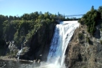
Montmorency Falls
After two days of independent touring, I joined the tour group and checked into the luxurious hotel Auberge Saint-Antoine in Lower Town. I visited more places in old Québec.
I traveled about 8 miles north of Québec to see the 272-foot high Montmorency Falls. It is formed from the Montmorency River as it tumbles over a high cliff.
Jacques-Cartier
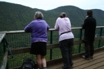
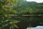
Parc national de la Jacques-Cartier
This national park is 31 miles north of Québec. It encompasses a part of the Laurentian Mountains and the Jacques-Cartier River. With lunch in my backpack and a hiking pole in my hand, I ascended a challenging trail to a wooden observation platform on the side of a mountain.
In the evening, I enjoyed fine-dining at Restaurant Initiale in Québec. After the rain has stopped, I took some night photographs of Québec.
Cap Tourmente
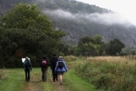
Cap Tourmente National Wildlife Area
Cap Tourmente is 31 miles northeast of Québec on the shore of the Saint Lawrence River. The tidal marsh is a habitat for migratory birds. The weather was a mixture of fog, dense cloud, and periods of shower. With lunch in my backpack and a hiking pole in my hand, I ascended a challenging trail to a wooden observation platform on the side of a mountain.
In the afternoon, I arrived at the hotel Auberge des 3 Canards in the town of La Malbaie in the Charlevoix region. La Malbaie is on the shore of the Saint Lawrence River about 90 miles northeast of Québec.
Hautes-Gorges
Parc national des Hautes-Gorges-de-la-Rivière-Malbaie
The national park is 25 miles from the town of La Malbaie. Its location in the Charlevoix region encompasses the Malbaie River, mountains, and valleys. I hiked a 5-mile level trail that closely follows the shore of the Malbaie River.
Tadoussac
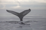
Town of Tadoussac
From La Malbaie, I traveled 46 miles northeast along the Saint Lawrence River in the Charlevoix region. I took a ferry to the town of Tadoussac at the confluence of the Saint Lawrence and Saguenay rivers. Minke, humpback, and beluga whales feed in this part of the river that has salt water from the Gulf of Saint Lawrence.
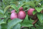
apple orchard
Island of Île d'Orléans
As the tour approach the end, I traveled back to Québec with a stop at the island Île d'Orléans in the middle of the Saint Lawrence River just 10 miles from Québec. I had lunch at Domaine Orléans, an apple orchard that also produces a variety of delicious apple cider. I tasted sparkling cider, flat cider, and ice-apple cider (cidre de glace).
In Québec, I visited a farmers' market named Marché du Vieux-Port in Lower Town. High quality fruits, vegetables, meats, cheese, wine, apple cider, confection, and baked goods from local producers were available.
Photographic Tools
- digital camera: Canon EOS 5D Mark II.
- zoom lens: Canon EF 75-300 mm F4-5.6 III USM.
- zoom lens: Sigma 24-60 mm F2.8 EX DG.
- memory: SanDisk CompactFlash.
- tripod legs: Slik Pro 714 CF II.
- tripod head: Acratech Ultimate Ballhead.
- camera bag: Lowepro Nova 4.
- photo processing: ImageMagick, Canon Digital Photo Professional, GIMP